This page works from that filing. Everything in the first half is drawn from it. Everything in the second half comes from the client brief in circulation, and is marked as such throughout, because none of it appears in any document we can verify. Where the honest answer is that a figure has not been published, that is what you will find written here. Nambiar Bannerghatta is useful for the site-planning lens because buyers should read open space, movement, parking, and amenity placement as everyday-use details, not brochure decoration.
What the Urban Oasis filing establishes about the site
The proposal is SIA/KA/INFRA2/587993/2026, a fresh application for Terms of Reference, last submitted on 7 August 2026 and currently under examination. It is classified Category B1 under Schedule 8(b), Townships and Area Development Projects — the class the regulator uses for schemes that build out a whole parcel rather than a single building. The promoter of record is M/s Urban Oasis, a partnership firm. Modern Spaaces lists the project on its own website among its upcoming villa developments off Sarjapur Road; building a project through a dedicated per-project entity is this developer's normal practice. The developer's own listing carries no acreage, unit count or survey number, so treating that listing and this environmental filing as the same scheme is our reading — the project name, the villa typology and the corridor all coincide, which is strong, but it is a reading and not a document.
| Item | Value in the filing |
|---|---|
| Land area | 14.6013 hectares = 36.08 acres |
| Total built-up area | 182,631.25 sq m |
| Residential units | 477 villas |
| Non-residential built element recorded | A club house |
| Building configuration | Ground floor plus two upper floors (GF + 2UF) |
| Maximum height | 11.0 metres |
| Declared project cost | Rs 426.94 crore |
| Land status | Acquired, assembled by sale deed, joint development agreement with land owners, and exchange deeds, with conversions obtained |
Two of those lines deserve immediate qualification. Rs 426.94 crore is a declared project cost, not a price and not a total sales value. We do not divide it by 477 to produce a per-villa figure on this site, because a declared project cost and a selling price are not the same quantity and presenting one as a proxy for the other would mislead. And "conversions obtained" refers to the conversion of the land from agricultural use — it is a land-title matter, entirely separate from approval of the scheme itself. The scheme has no approval of any kind.
Material in circulation quotes a marginally larger land area than the filing does. The figure to work from is 36.08 acres, which is what the government record states, as 14.6013 hectares.
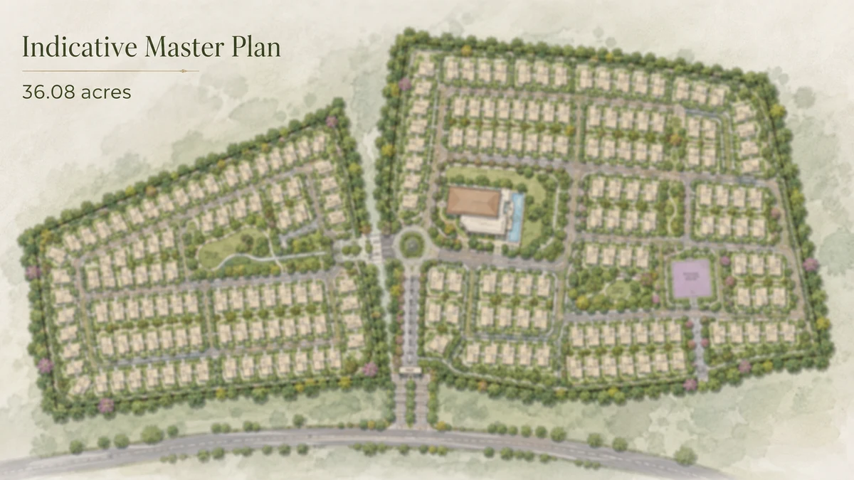
The land: 25 survey numbers across two revenue villages
The parcel is not a single holding. It is an assembly of 25 survey numbers spread across two revenue villages, both in Sarjapura Hobli, Anekal Taluk, Bengaluru Urban District.
| Revenue village | Village code | Survey numbers on this parcel |
|---|---|---|
| Yamare (census spelling "YAMRI") | 613217 | 97/1, 97/2, 98/1, 98/2, 100/1, 100/2, 100/4, 101/1, 101/2, 102/1, 103/1, 103/2, 103/6, 103/18, 103/19, 103/20, 103/21, 103/22, 103/23, 103/24, 103/25, 103/26 — 22 numbers |
| Dommasandra | 613354 | The remaining 3 numbers |
The postal address is Dommasandra Post, 562125. Written out in full, the address is Yamare and Dommasandra Villages, Sarjapura Hobli, Anekal Taluk, Dommasandra Post, Bengaluru 562125.
Some material in circulation places the project at Kommasandra. Kommasandra is not one of this parcel's revenue villages and does not belong in its address — but it is a real neighbouring village, code 613207, under Muttanalluru Gram Panchayat on the Chandapura–Dommasandra road, and its place node sits about a kilometre from the parcel. It is a nearby village that has been attached to the wrong address, not an invention.
The assembly matters for reading the site plan when one eventually appears. A 25-holding assembly built up through sale deeds, a joint development agreement and exchange deeds rarely produces a rectangle. Boundaries follow old field lines. That is normal, and it is one reason a buyer should look at the sanctioned layout rather than a marketing render when it is finally available.
Where the parcel sits, and how precisely we can say so
The boundary file lodged with the application is named "final urban oasis_project site 21.07.2026.kml". Its bounding box has corners at 12.86419, 77.74645 and 12.86796, 77.75291.
We publish the centre of that box as the project location: 12.86607, 77.74968. That is our own derivation, at medium confidence, and it is not an exact site coordinate. The bounding box measures roughly 417 metres north to south and roughly 701 metres east to west — about 29.2 hectares of enclosing rectangle around a 14.6-hectare parcel. The land fills something close to half of the box it sits in, and it is genuinely elongated on the east–west axis. Treat the coordinate as a reliable pointer to the right field, not as a surveyed corner.
For context on the immediate setting, and using road distances only: Dommasandra Lake is 1.30 km away by road and Yamare Lake is 2.56 km by road.
Density at Urban Oasis: our arithmetic, shown
The filing gives a unit count and a land area, so the density follows directly. The figures below are our own derivations, marked as estimates, computed from the two verified numbers.
| Derivation | Working | Result |
|---|---|---|
| Villas per acre | 477 ÷ 36.08 acres | about 13.2 villas per acre |
| Gross site area per villa | 36.08 acres × 43,560 sq ft = 1,571,645 sq ft; ÷ 477 | about 3,295 sq ft per villa |
| Gross site area per villa, metric | 146,013 sq m ÷ 477 | about 306 sq m per villa |
| Built-up per villa, gross | 182,631.25 sq m ÷ 477 = 382.9 sq m | about 4,121 sq ft per villa |
Thirteen villas to the acre is the figure to hold on to. It is the whole site divided by the whole unit count — every square foot of internal road, every metre of the club house footprint, every drain and every setback included. The private plot each buyer actually owns is necessarily smaller than 3,295 sq ft, because roads, the club house, common open space and services all have to come out of that same 3,295.
There is a second ratio a reader will sometimes ask for: total built-up divided by land area, which is 182,631.25 ÷ 146,013, or about 1.25. This is not a floor area ratio and must not be read as one. The covered-area figure in an environmental filing is defined for that filing's purposes and is not the same base a planning authority uses when it fixes FAR. We publish the ratio only so nobody has to guess at it.
Built-up area per villa, and the conclusion it does not support
The 4,121 sq ft figure above is arithmetically correct and analytically limited. 182,631.25 sq m is total covered construction across the whole site. It includes the club house, service and utility blocks, security structures, the sewage treatment plant and overhead tanks, porches and balconies. It is not the same quantity as a marketing "built-up area" for one villa.
The brief in circulation describes two configurations, with built-up areas of 3,300 sq ft and 4,200 sq ft. Both figures are unverified. It is tempting to line the derived 4,121 sq ft up against those two numbers and conclude something about how the 477 villas are split between the configurations. That conclusion does not follow and we do not draw it. The two quantities are not measured the same way, so the comparison cannot support a mix. Anyone telling you the scheme is predominantly one villa type is not getting that from the filing.
GF plus two upper floors, capped at 11.0 metres
The filing's height line is unusually useful for a buyer trying to picture the place. Ground floor plus two upper floors, with a maximum height of 11.0 metres, is a low-rise envelope across the entire 36.08 acres. Eleven metres is roughly the height of a three-storey house including its parapet — there is no room in that number for a tower, a stilt-plus-four block, or anything that would break the roofline.
Practically, that means the internal streets will read as streets rather than as canyons, that sightlines across the site stay long, and that no unit in the scheme is more than two flights above its own front door. It also means the density of about 13.2 villas per acre is achieved horizontally, by plot size, rather than by stacking. That is the defining structural fact about how this scheme occupies its land, and it is verified.
The club house is the only common facility the filing records
Within the 182,631.25 sq m of built-up area, the filing records a club house. That is the one common built facility named in the document, and we lead with it because it is the one we can stand behind.
The amenity list attached to the client brief is not published on this page. It is boilerplate — the identical list appears against an unrelated 1,352-home apartment high-rise — and it contains nothing specific to a villa scheme. Publishing it here would tell you about a template, not about Urban Oasis. No size, no floor area, no facility schedule and no location within the site has been published for the club house. When a sanctioned layout appears, the club house footprint is one of the first things worth checking, because in a 477-home low-rise community it is the shared indoor space the whole population draws on.
The client brief's site-planning claims: attributed, and none of them verified
The following figures come from the client brief in circulation. None of them appears in the accessible filing. They are set out here in one place, attributed, so that a buyer can see exactly what is being claimed and exactly what stands behind it, which at present is nothing we can check.
| Site-planning claim | What the brief states | Status |
|---|---|---|
| Landscape share of site | 33.23 per cent | Unverified — brief only |
| Civic amenity area | 7,093.28 sq m | Unverified — brief only |
| Parking spaces | 1,049 | Unverified — brief only |
| Approach road width | 12.10 m | Unverified — brief only |
| Villa plot sizes | 1,800 – 2,400 sq ft | Unverified — brief only; a single project-wide range, not split by configuration |
A note on that last row. The brief gives the plot range once, for the whole project. It does not assign 1,800 sq ft to one configuration and 2,400 sq ft to the other, and neither do we. Anybody quoting you a plot size for a specific villa type is going beyond the material.
Several other items a buyer would reasonably want are simply absent. No treatment capacity is published for the sewage treatment plant, no count of groundwater recharge structures, no sanctioned electrical load and no buffer widths along the parcel's edges. None of those numbers appears in anything we can verify, so none is published here. An absent figure is better left absent than filled in with a plausible one.
The brief also lists a set of sustainability measures: rainwater harvesting, groundwater recharge, reuse of treated sewage for landscaping and flushing, solar photovoltaics, and reuse of excavated topsoil and construction waste. These read like commitments drawn from an environmental submission and are plausible for a scheme of this class, but they are uncorroborated and are recorded here once, as the brief's claims, and nowhere else on this site.
The landscape percentage, read honestly
Set the brief's 33.23 per cent landscape beside its own plot range and the verified site area, and the arithmetic is tight. 477 plots at 1,800 sq ft consume about 54.6 per cent of the 36.08-acre site (477 × 1,800 = 858,600 sq ft, against 1,571,645 sq ft of gross site area). At the top of the range, 2,400 sq ft each, the plots alone account for about 72.8 per cent. Both of those are our arithmetic on the brief's own numbers.
Our reading, and we offer it as a reading rather than a finding: the 33.23 per cent landscape most likely counts private open space inside the villa plots — the garden and setback area a buyer owns — rather than a third of the site held as common parkland. That is ordinary practice in villa schemes and it reconciles the figures without strain. What it changes is the resident's experience: a third of the site under greenery, most of it inside individual compound walls, is a different place from a third of the site as shared park.
What the brief's claims would mean for an Urban Oasis resident, if they hold
Each of the brief's numbers implies something concrete for someone living there. Read the following as conditional throughout — every one of them rests on an unverified figure.
Parking, at 1,049 spaces. Across 477 villas that works out to about 2.2 spaces per home (1,049 ÷ 477 — our arithmetic on the brief's count). In a low-rise villa community, parking is normally within each plot, as a porch or covered bay, with additional visitor spaces along the internal streets. A ratio above two would mean provision for a second car per household with something left over for visitors. That matters more than it sounds: in schemes where visitor parking is thin, cars end up on the internal roads, and internal roads in a low-rise community double as the place children walk and cycle.
Civic amenity, at 7,093.28 sq m. That is about 1.75 acres, or roughly 4.9 per cent of the 36.08-acre site, by our conversion. A civic amenity reservation is land set aside within a layout for community uses rather than for sale as housing. Whether it is developed by the promoter, handed over, or held vacant for years varies enormously from scheme to scheme — and the brief does not say which applies here, or where on the site the reservation sits.
The approach road, at 12.10 m. The approach road is what connects the scheme to the public network, and its width sets a ceiling on how comfortably 477 households enter and leave. Twelve metres allows genuine two-way movement with room for service and emergency vehicles. It is worth confirming from a sanctioned drawing rather than a brochure, because a stated approach-road width and the width actually available on the ground at the tightest point are not always the same thing.
The sustainability measures. Treated-sewage reuse for landscaping and flushing, if implemented at capacity, reduces a community's draw on tankered and borewell water — which on this corridor is the running cost that most often surprises buyers. Rainwater harvesting and recharge structures work on the same problem from the other end. But without a published capacity, a recharge count or a maintenance commitment, these are intentions on paper. Ask what the treatment capacity is, and ask who pays to run it.
No sanctioned layout for Urban Oasis has been published
This needs stating without hedging, because it governs everything above.
There is no approved master plan for Urban Oasis. There is no sanctioned layout drawing. Nothing has been granted. The environmental application is under examination. There is no Terms of Reference, no environmental clearance, no signed certificate, no state file number and no central file number in the public record — those fields are empty, not pending-with-a-document-behind-them.
The boundary file lodged with the application is a polygon of the site's extent, not a layout. It tells you where the land is. It does not show a single road, plot line, park or building footprint. Any site plan circulating as "the master plan of Urban Oasis" is therefore a marketing illustration, and should be treated as one until a sanctioned drawing from the planning authority exists to compare it against.
Separately from all of the above: Urban Oasis is not registered with the Karnataka Real Estate Regulatory Authority, and carries no RERA registration number. Under Section 3 of the Real Estate (Regulation and Development) Act 2016, a project in a registrable class may not lawfully be advertised, marketed, booked or sold until registration is granted. An expression-of-interest campaign for this project is live. This microsite is an information and enquiry resource for a scheme at the approvals stage — it is not a booking channel, and no booking can properly be taken on this project today.
What to ask to see, before the Urban Oasis layout is public
If you are tracking this scheme, the following documents are the ones that would convert the second half of this page from claims into facts.
| Ask for | What it settles |
|---|---|
| The sanctioned layout plan from the planning authority | Plot lines, road widths, park locations, the club house footprint — everything currently unpublished |
| The Terms of Reference, once granted | Confirms the appraisal conditions the scheme must meet; none exists today |
| The K-RERA registration certificate | The legal precondition for any booking; not registered at present |
| Plot dimensions for the specific plot you are shown | The 1,800–2,400 sq ft range is project-wide and unverified |
| The club house area and facility schedule | The only common facility the filing names, with no published detail |
| Sewage treatment capacity and who operates it | Absent from everything we can verify |
For a villa-format scheme on the same corridor to look at alongside this one, Nambiar District 25 sits 4.45 km away by road and is the nearest villa-format project in our coverage.
We will update this page when there is a drawing to describe rather than an application to report.
Urban Oasis by Modern Spaaces Master Plan — frequently asked questions
How large will each Urban Oasis villa be, going by the filed built-up area?
You can do one piece of arithmetic here and no more. The filing gives 182,631.25 sq m of total built-up area for 477 villas, which works out to roughly 4,121 sq ft of gross built-up per villa as an estimate. Stop at that number. It is not a marketing built-up figure and is not comparable to one: the filed total is all covered construction on the site, which includes the club house, service and utility blocks, security structures, the sewage treatment plant, overhead tanks, porches and balconies. Nothing about the mix of villa types can be inferred from it. If you see a claim that the project must be predominantly the larger configuration because of this division, that claim is unsupported.
What does the absence of RERA registration actually mean for me as a buyer today?
It means the protections you may be assuming are not yet in place. Registration is what puts the project's approvals, layout, promoter details, unit inventory, carpet areas and a committed completion date on the public record. It is also what brings the escrow discipline on collections, the standard agreement terms and the authority's complaint mechanism into play. Until it is granted, none of that applies to Urban Oasis. Practically: there is no registered carpet area to hold anyone to, no registered completion date, and no registered inventory against which a claimed allotment can be verified. Any money paid at this stage sits outside the statutory framework entirely.
Which survey numbers does the land cover, and does the developer already control it?
In Yamare: Sy. Nos. 97/1, 97/2, 98/1, 98/2, 100/1, 100/2, 100/4, 101/1, 101/2, 102/1, 103/1, 103/2, 103/6, 103/18, 103/19, 103/20, 103/21, 103/22, 103/23, 103/24, 103/25 and 103/26 — 22 numbers. Three further numbers fall in Dommasandra. On control, the filing records the land status as acquired, assembled through "sale deed, JDA from land owners and exchange deeds", with conversions obtained. That is a meaningful disclosure: it says the promoter is not working on an option or an unexecuted agreement across the whole parcel. It also flags that a joint-development component exists, which is worth asking about, because JDA terms determine who can convey title on which units.
What does a villa at Urban Oasis cost?
There is no price. The developer has published no rate, no unit price and no payment plan for Urban Oasis, and this site publishes none. That is the correct position for a project that is not registered: a promoter cannot lawfully offer units for sale before registration, so a published price at this stage would itself be a problem rather than a convenience. Enquiries at this stage are enquiries, not bookings. When a rate does appear, note that villas are usually better compared on an all-in figure per villa than on a rate per square foot, because the land share dominates the price of a plotted product in a way it never does in an apartment.
A per-square-foot rate for Urban Oasis is circulating online. Is it genuine?
We checked, and no. A channel-partner page is being cited as the source of a specific per-square-foot expression-of-interest rate for this project. We examined that page's HTML, its scripts and its structured data. The quoted figure appears nowhere in any of them; the page's own visible price field shows no figure at all. The number has no source at all, which is why this site will not repeat it even to argue with it. The same page also carries an acreage and a villa count that contradict the filed record, so it may not describe this scheme accurately in the first place. Treat any pre-launch rate for Urban Oasis, from any party, as unsourced until the developer publishes one.
Enquire about Urban Oasis by Modern Spaaces
Urban Oasis by Modern Spaaces is at the stage where the useful thing is information rather than a booking, because there is no lawful booking to make. Leave your details and we will tell you when the position changes — when a Karnataka RERA number is issued, when the environmental file moves, and when the developer publishes a price, a floor plate and an amenity schedule. The enquiry form asks for a name, phone number, email address and message; name and phone are required.